![](/images/other/stat-length.png)
![Tour Zu Fuß Somerset West and Taunton - Walking in Exmoor: Day Two - Photo](https://media.geolcdn.com/t/1900/400/810cbec9-f9c7-401b-a558-7014bddd9709.jpeg&format=pjpeg&maxdim=2)
Walking in Exmoor: Day Two
SityTrail - itinéraires balisés pédestres
Tous les sentiers balisés d’Europe GUIDE+
![Länge](/images/other/stat-length.png)
Länge
25 km
![Maximale Höhe](https://static1.geolcdn.com/siteimages/upload/files/1508320355ic_sort_altitude_max_24dp.png)
Maximale Höhe
517 m
![Positive Höhendifferenz](https://static1.geolcdn.com/siteimages/upload/files/1508320355ic_sort_den_pos_24dp.png)
Positive Höhendifferenz
778 m
![Km-Effort](/images/other/stat-length.png)
Km-Effort
36 km
![Min. Höhe](https://static1.geolcdn.com/siteimages/upload/files/1508320355ic_sort_altitude_min_24dp.png)
Min. Höhe
33 m
![Negative Höhendifferenz](https://static1.geolcdn.com/siteimages/upload/files/1508320355ic_sort_den_neg_24dp.png)
Negative Höhendifferenz
776 m
![Boucle](https://static1.geolcdn.com/siteimages/upload/files/16400158638029165_repeat_loop_refresh_sync_direction_icon.png)
Boucle
Ja
Kennzeichnung
Erstellungsdatum :
2025-02-05 14:34:54.969
Letzte Änderung :
2025-02-05 14:34:54.969
![Zu Fuß](https://static1.geolcdn.com/sitytour/trail-icons/100.png)
8h04
Schwierigkeit : Schwierig
![Scannen Sie diesen QR-Code, um die Tour in der SityTrail-Anwendung zu öffnen](https://capi.geolives.com/qq0zvz2zws4bq2lad0pu/sitytour/trails/4341748/qr.png?size=200)
Kostenlosegpshiking-Anwendung
Über SityTrail
Tour Zu Fuß von 25 km verfügbar auf England, Somerset, Somerset West and Taunton. Diese Tour wird von SityTrail - itinéraires balisés pédestres vorgeschlagen.
Beschreibung
Tour erstellt von National Trust.
Part two of a two-day walk on the Holnicote Estate.
Ort
Land:
United Kingdom
Region :
England
Abteilung/Provinz :
Somerset
Kommune :
Somerset West and Taunton
Standort:
Unknown
Gehen Sie:(Dec)
Gehen Sie:(UTM)
460405 ; 5672515 (30U) N.
Kommentare
Touren in der Umgebung
![Tour Zu Fuß Somerset West and Taunton - Walking in Exmoor: Day One - Photo](https://media.geolcdn.com/t/375/260/3735f2aa-2707-462c-8979-45c30cf7e926.jpeg&format=jpg&maxdim=2)
![Zu Fuß Zu Fuß](https://static1.geolcdn.com/sitytour/trail-icons/100.png)
Walking in Exmoor: Day One
Zu Fuß
Einfach
Somerset West and Taunton,
England,
Somerset,
United Kingdom
![](/images/other/stat-length.png)
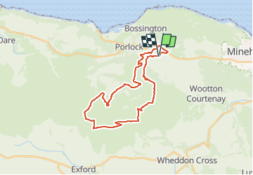
7,9 km | 11,9 km-effort
2h 42min
![](https://static1.geolcdn.com/siteimages/upload/files/16400158638029165_repeat_loop_refresh_sync_direction_icon.png)
Nein
![Tour Zu Fuß Somerset West and Taunton - Selworthy and Bury Castle circular walk - Photo](https://media.geolcdn.com/t/375/260/b30fb0f5-e2ed-422e-b913-500c56dc2ad7.jpeg&format=jpg&maxdim=2)
![Zu Fuß Zu Fuß](https://static1.geolcdn.com/sitytour/trail-icons/100.png)
Selworthy and Bury Castle circular walk
Zu Fuß
Einfach
Somerset West and Taunton,
England,
Somerset,
United Kingdom
![](/images/other/stat-length.png)
5 km | 7,3 km-effort
1h 39min
![](https://static1.geolcdn.com/siteimages/upload/files/16400158638029165_repeat_loop_refresh_sync_direction_icon.png)
Ja
![Tour Zu Fuß Somerset West and Taunton - Dunkery and Horner Wood circular walk - Photo](https://media.geolcdn.com/t/375/260/a76ad9a4-82c6-4e35-9cff-20479b372de7.jpeg&format=jpg&maxdim=2)
![Zu Fuß Zu Fuß](https://static1.geolcdn.com/sitytour/trail-icons/100.png)
Dunkery and Horner Wood circular walk
Zu Fuß
Einfach
Somerset West and Taunton,
England,
Somerset,
United Kingdom
![](/images/other/stat-length.png)
4,4 km | 6,8 km-effort
1h 33min
![](https://static1.geolcdn.com/siteimages/upload/files/16400158638029165_repeat_loop_refresh_sync_direction_icon.png)
Ja